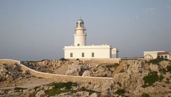
Lighthouses
Lighthouses have been used in many films, generating auras of romance and airs of courage, strong landmarks withholding raging seas, saving the lives of lost mariners on rough or fog ridden seas. Maybe their use has diminished but never the less these isolated buildings still capture the imagination of most and yet when the winds die, these lighthouses, often situated in isolated landscapes offer an amazing quality of peace, a rich sea smell and a good perch to watch the coastal sea and cliff life.
Cap de Cavallería

This beautifully situated lighthouse to the north of Es Mercadal, was built in 1857, it is built 90 meters above the sea level, and has dramatic cliffs surrounding it. According to records, one year prior to its construction there were eight shipwrecks in the area. The actual light is now run by solar panels and batteries – and it can shine up to 36 miles.
Cap d'Artrutx
Built in 1858 and situated on the farthest south point of Ciutadella. Constructed to a height of 36 meters, with the traditional black and white markings, it also had a keeper’s home with an interior patio and a high stone wall surround. In 1968 the tower was raised a further 17 meters and four reinforced bases were laid to help its stability.
Illa de l'Aire
Built in 1860, on the island of the, Illa de l’Aire in Punta Prima, Sant Lluís. Its Light shines over thirty miles. Its tower reaches 36 meters and it is built 52 meters over the sea level.
Punta Nati
This lighthouse to the north of Ciutadella was built after the sinking of the “General Chanzy" in 1913, only one sailor survived from that terrible affair.
Favaritx
The most modern of our islands lighthouses, this one to the north of Maó, was built in 1922, to ease the shipwrecking that was common in the area. The tower has a height of 30 meters and it shines over a span of 26 miles. The materials for its construction were taken from its area; it was both cheaper and easier.
This solitary cape, whipped by the stormy tramontana wind, is one of the oldest geographic sites on the island. In between the slate, you can find fossils of the first creatures to live here; crustaceans and small marine animals from several thousand years ago.
Something special vibrates in the air here, which grows in the moonlit nights, when the slate rocks turn to silver in the rocky loneliness. There isn´t any other place like this in Menorca. It is a moving, positive and artistic inspiration.
At the end of the road which leads to the lighthouse, a great space gathers the water flooded in from the storms. Tradition tells that on moonlit nights, if you walk through these magic pools, you will receive the strength, energy and fertility of both moon and sea.
There are five lighthouses which can be visited around the island.
- Radio light house in the Castle of San Felipe (Es Castell): It was an active lighthouse between 1852 and 1912, continuing to shine over the port from 1916 until 1961, when it then became a radio lighthouse. It has 12 meters of height and a Light span of 19 miles.
- Sa Farola: constructed in 1860 at the mouth of the harbour of Ciutadella. It was the last to have a keeper. Its light radiates an area of 10 miles; it was built 20, 35 meters over the sea and has a tower of 11 metres.
Monte Toro

The islands icon is a compulsory visit as it is the islands highest point, a height of 357.96 meters. On a clear day from this “balcony in the skies” and with the help of a map you can pin-point the different places of the island and enjoy the stunning views and landscapes.
Built on the summit, is a gothic church and refuge, called the “Santuario de la Virgen del Toro” which was constructed during the 17thC. One of the focal points of the church, is the statue of “La Virgen de la Mare de Déu Del Toro”, the patron saint of Menorca.
El Toro, is also an important fire watch point, particularly active during the summer months.
A small shop is run by the resident sisters, and the church also rents out a larger shop and the old “posada”. This bar is a successful rest place for all travellers and somehow the food tastes different when enjoyed 357 meters above sea level.
On arriving you will see a sculpture of “Christ on the cross” similar to that can be seen in Rio de Janeiro.
El Toro and the church entrance are free, though one is requested to respect a dresscode.
Church services are held every Sunday and on public holidays at 11.00 a.m
La Albufera d'Es Grau

Albufera des Grau has a special bio-topography and has a sweet water lake which merges with the sea water. This lake covers an area of 70 acres providing an environment rich in flora and fauna and also providing a rest stop for migratory birds passing through between Africa and Europe. As a result of these rich lands Albufera is and has been since 1995 an “Area of Natural and Special Interest” and registered with the central government.
Es Grau, is a quaint, timeless sea side village, a perfect summer refuge for the locals who purchased their second summer homes close to the sea. The village is a perfect back drop – no high rise buildings, no hotels and no holiday resort trappings, there are four bars, which offer snacks, menus and tapas and a supermarket.
The long sandy beach of Es Grau is a haven for younger and less confident swimmers as the bay is very shallow. During the summer months there is a Red Cross point in operation and assistance for disabled persons.
Walking around the beach along the coastline you come across a super viewing point, to the north-west you have the lighthouse of Favaritx, and to the north east you have the “isla del Colom”.A unique excursion operating during the summer from the Es Grau pontoon is a boat taxi service, offering return trips to this island. This is an island with nothing but two beautiful sandy beaches.
Barranco d'Algendar

One of islands most famous gorges, is the Gorge of Algendar (Ferreries) It starts from the springs of Santa Agueda (old roman fortress) and s’Enclusa (old American base) and weaves its way towards Cala Galdana in the south. The gorge is10 Km long in total and its depth of 80 meters is scattered with natural caves. The gorge´s terraine has a rich soil and at one time the many caves were occupied by Arabic farmers during the Muslim occupation.
Barranco d'Algendar Legend
In the centre of the gorge, close to the "Cases del Bisbe" (Bishops houses) is a particularly hazardous spot, covered with wild vegetation and shrubs- It is here that legend says that the thief "Revul" lived.
He was not a particularly romantic thief, this Arab with wild hair stole from the local farmers and then returned to his secret hideout. Throughout the years, the locals tried without success to find Revul within this maze of vegetation.
One of the magic spots within the gorge is the cave “Cova Murada” a large abyss with ancient mysteries which for many years was hidden by a stone wall. The legend says that this was the home of the lady, “la Dama”.
The legend says that this was the home of the lady, “la Dama”. According to legend, within this great cave, a goat shepherd used to rest with his herd. One day, by surprise he spotted the princess holding a golden comb in her hand. Neither parties spoke. On the second day when he saw the princess again he was aware that she was wishing to initiate a conversation – but he chose to ignore her. On the third day, the princess broke into conversation, asking “What do you prefer, the lady or the comb?” Ungallantly he chose the comb, to which the lady was furious, wielding her comb in the air and cursing him to a lifetime of poverty.
Before the Islamic domination, all this area formed part of Santa Ana. Once the moors arrived, the word “Santa” was replaced by their naming of the river that passed through the gorge: Guad-al-Ana, or the river of Ana. These places still possess a magical air with their stories of caves and giants, their natural environment, hidden in shadows and a landscape where there are still corners where it seems that time stands still.
Cova d'Es Coloms

Sa Cova des Coloms, (Colom cave or Catedral cave) is a enormous cave situated in the gorge of Binigaus (Es Migjorn) It has a height of 24 meters, a depth of 110 meters and a width of 15 meters.
Its name derived from the birds who took refuge in its interior, hiding from local hunters, for its bats and its actual size, representing that of a Cathedral.
Prehistoric discoveries were found in the cave, which are today safely guarded in the Menorcan museum (Mahon).
It is thought that these prehistoric settlers possibly used this cave for rituals, assuming that the cave represented the forces of the underground, and that the depth represented shelter and warmth, like a womb. They truly believed that the cave represented a journey into the beginning of life, they supported that death and birth were one, i.e. one could have no death if their was no life.
One of the curiosities of the cave is that if two people enter the cave simultaneously – they will separate, yet, if two people meet together at the end of the cave, they will never be apart.
The cave in spring receives the first rays of sun, forming shadows on the walls, it certainly looks mythical and one can appreciate the stories of gods, goddesses and giants roaming the interior.
Santa Àgueda mountain

This high point, close to Ferreries was the natural base for a roman fortress. It was later occupied by the moors, intellectuals and artists who passed their summer months within the grounds. When the Spanish, under Alfonso III re conquered the island from the Muslims, Santa Agueda was the final battle ground. Unfortunately, this once palatial -fortress with beautiful gardens has been reduced to ruins over the years.
Legend of Santa Águeda mountain
The legend speaks of a treasure, the treasure of “Vadell d'or", a treasure hidden by the Muslims prior to their sudden departure from the island. They had faith that the spirits, fairies, witches and the goddess of Santa Agueda and the surrounding area would guard the treasure.
Santa Agueda was also subject to peregrine marches, people who believed that the mountain was good for chest problems. Legend writes that the mountains were visited by sailors and fishermen, seeking protection for their journeys and saving them from the rigors of the winds and illness.
Sa Nitja

This is a natural shelter against the angry seas and tramuntana wind, this small harbour is narrow and long and houses a small island.
Today, wild goats are the only habitants of this environment although legend says it houses an underwater city, called “el Mediterráneo”.
The great roman chronicler, Plinio the Elder, describing the towns in Menorca, refered to: Jammo (Ciutadella), Magona (Mahon) and “Sannicera”. Even Pedro Martel, when he described the island of Jaime I during the preparing of the conquest for the Crown of Aragon, mentions the”Port of Sereyna”, the same that appears in the catalan 1375 Atlas as “Senija”. Throughout history, this place has had various names, depending on those who have conquered, and used it as a landing site: Samnicera, Janissari, Sanisera,Senija,Sanitja ….
Archaeologists have proven the area to be of Phoenician founding, an important nucleus and defence area with temples and a necropolis. Under the Romans the area flourished.
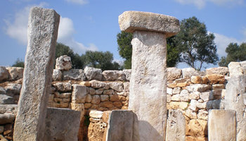
Not far from there, on the heights of Es Pujol de Cavallería, exists a “taula”, broken by lightning, as testimony that the pre-historic villagers also considered it to be a sacred place. This is the most northern of the megalithic constructions on the island and the only known taula pointing north. A tiny statue of Mars the Warrior was found here, also the remains of a semi-circular wall, which, according to archaeologists, formed part of a lighthouse showing sea traffic the way – predecessor to the modern lighthouse that you find there today.
For the traveller today only the necropolis exists to the visible eye, but the secret is what lies under the water.
In fact, all Sa Nitja is an archaeological paradise still to discover – not only the remains that one can see today, but also those which are in the sea depths. The mystery of the parcially submerged city has created all sorts of myths and legends about this place.
Madó Alzina, former farm worker of Santa Teresa, told the investigator,Francesc Camps, that the statue of the Virgen Carmen which exists in the chapel of this property came from the ancient under-water city, Ses Vilotes.
Another legend tells us of a bishop, who for some unknown reason had been condemned to death. They tied him to a chain and drowned him in the port at a place now so called “the canal of the chain”. The old folk declare that one day, whilst working on the land nearby, they found the chain that had drowned the bishop, but of him, it is said, no trace was ever found .
Lazareto Island.
Situated in the port of Mahon, just opposite the pretty port of Cala Fons is the island of Lazareto. This island was used as a quanantine base or all domestic and international maritime traffic and stock entering Menorca.
sailors and travellers who entered the port with a plague on board, the other was for the crews of ships with non infectious cases aboard and the third was for healthier crews with individual small cases of illness.The corpses were deposited in a communal sea grave, by the cove on the other side of Calas Fonts, this cove was unceremoniously known as Cala Corp. Cala Corb as its known today.
Menorca´s fortresses

The port of Maó has always attracted naval powers, pirates and tradesmen, and therefore it’s not surprising to see it dominated with military fortifications. Upon entering the harbour (a highly recommended excursion) you can see that the south cliff has one military base (San Felipe) and on the north cliff, another majestic castle (La Mola):
located on the south side, Saint Philips Castle (Castillo de San Felipe), was originally started in the mid 18th C under the Spanish but on many occasions under British domination it was extended and the British were responsible for its star shaped feature which is still visible today. Under the Spanish King, Carlos III he had the fortress dismantled merely to prevent the fortress falling into the hands of other invaders.
The north cliff, incredibly high in relation to the remaining lands, was the home for the construction of the magnificent La Mola Fort .built under the Spanish rule of Isabel II, to protect the island from invaders. La Mola in Spanish means molehill, an adequate name to reflect the countless underground tunnels present in its design. The fort has seen countless battles and under the Spanish rule of Alfonso XIII,, he had 18 canons of 381mm (from Vickers) which were actually destined for his galleons, but placed on La Mola because he did not have the sea vessels available. These guns measured 17, 60 metres in length and weighed 88 tons, with a 270º rotation; the guns could fire a distance of 35 km, and were capable of perforating an iron ship with a 36 cm thickness at a distance of 23 km. Fortunately they were never fired against any foe and were used merely for military practices right up to 1911. La Mola has seen recent restoration and is administered as a business by a hotel group who paid for the work; however La Mola is open dailly to the public and hold regular guided tours and other activities throughout the year.
It's high recommened to visit both fortresses specially the Castle of San Felipe, has just started with summer visits and guided trips, a particularly interesting one is their evening trip, which enables you to enjoy a guided trip in English holding your own lantern and watching professional actors re-enact scenes from the military past and firing of a XVII canon and bayonet gun.
Other military premises to include in your visits are:
- Fort Malborough: in the Cove of San Esteban, built by the British during 1710 & 1726, to act as a second support post to their neighbouring military base of San Felipe. The fort was named after General Sir John Churchill, the Duke of Marlborough. The actual building was built below land and thus hidden from the naked eye. The fortress was not destroyed so fortunately even today its possible to view the original tunnels and rooms. The military archaeologists still feel that there is a tunnel which goes under the sea to the base of San Felipe. The fortress is open to the public and has regular guided tours, held in different languages.
- Minorca Military Museum (Museo Militar de Menorca): Situated in the main square of Es Castell, and built by the British in 1711. There are eleven exhibition rooms depicting the military history of the island. Canons and guns are on display with a Vickers 381 mm.
La isla del Rey (King's Island)
In the middle of the Port of Maó, approximately half way between the mouth of the port and the colársega, you find the Isla del Rey (King Island), called this because in 1287 it was the first land trod by the Spanish King, Alfonso III, during his campaign to conqueror Menorca from the Muslims. Prior to this, the island was referred to as Rabbit Island.
The island has a surface area 41.177 sq.mts. and is triangular in form, it has two embarkation areas, one in the north and the other in the south, the latter being utilized more due its proximity to Cala Fontanillas, in Es Castell. The island is occupied by the old military hospital located on the east side, a closed enclosure surrounding and protecting the remains of the basilica (dated 6th Century).
During the 18th Century shortly after taking his seat, the 1st British Governor expropriated the island from its owners with the intention of constructing a sailor’s hospital. Under the command of John Jennings, of the British Mediterranean Fleet, in 1711 a spacious and airy hospital was built, and according to records remained an active institution for the following sixty years until it was substituted during the second British occupation for a newer building, similar to the Chelsea hospital in London
On the 30th October 1771, during Governor Moystins epoch and under great pomp and circumstance, the acting Admiral of the Mediterranean Fleet, Baron Sir Peter Dennis laid the 1st stone. This act was commemorated with an engraved copper plaque, which was accidentally found in 1906 following restoration work, and visible today. During this period the hospital had 40 wards for the sick and needy, varying rooms for the medical staff, a pharmacy, a laundry, the kitchens, bathrooms and three natural water wells.
The island has been well used, by the British (as a hospital base) the Americans ( a military base, naval workshop and introduction of the sewing rooms) By the French on two episodes ( natural coal base to cover the Algerian line and as a hospital during the African wars) and after so many uses the island from 1843 recuperated her former role as a military hospital, a Spanish base which was maintained for over a century until her end and demise in 1964, unfortunately by closing the doors of the Hospital on the Isla del Rey it opened the way for petty pillage and destruction.
In 1979 – the Island was declared a National Historical & Artistic Monument with special archaeological emphasis on the chapel and the adjacent buildings.
After some wild plans to build a casino (Richard Branson) and a Japanese funded five star hotel – the island saw in the year 2004 the first signs of active and elegant restoration, not by the local government bodies but by a small group of volunteers and private funding. A team from menorca rentals assist when possible.
Summer 2008 saw the first private visit of the present King Juan Carlos to visit the work of the Friends of the Island Group and the installations of the island.
Guided visits are available throughout the year, every Sunday at 08.45 from the Fontanillas pontoon in Es Castell (weather permitting) return two hours later.